Showing 1–100 of 119 resultsSorted by latest
-
€150.00 plus VAT if applicable.
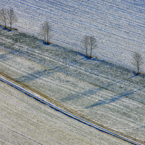
Aerial view of a row of trees at the edge of a field in Vatersdorf, Landshut, Lower Bavaria
-
€150.00 plus VAT if applicable.
Aerial view of a green strip in a still young cornfield in Ering, Rottal-Inn, Lower Bavaria
-

€100.00 plus VAT if applicable.
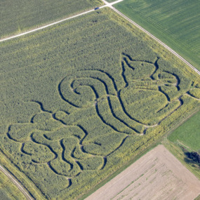
Aerial view of the corn maze in Chieming, Traunstein, Upper Bavaria
-

€100.00 plus VAT if applicable.
Aerial view of hop poles in the snow in Enghausen near Mauern, Freising, Upper Bavaria
-

€100.00 plus VAT if applicable.
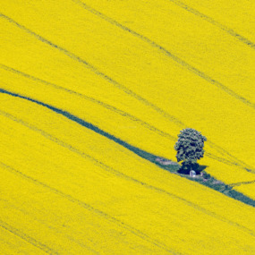
Aerial view of the end of a green hedge in a flowering rapeseed field in Aich near Moosburg, Freising, Upper Bavaria
-

€100.00 plus VAT if applicable.
Aerial view of an asparagus field white-lined with a gully in Inchenhofen, Aichach-Friedberg, Swabia, Bavaria
-

€150.00 plus VAT if applicable.
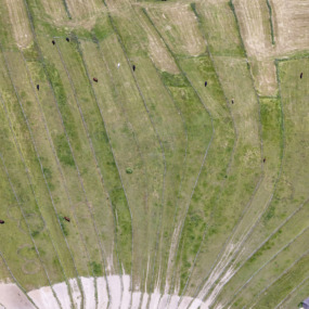
Aerial view of the hay harvest at Dullinger in Tuntenhausen, Rosenheim, Upper Bavaria
-

€100.00 plus VAT if applicable.
Aerial view of a rectangular agricultural landscape with rapeseed blossom in Niedererlbach near Buch am Erlbach, Landshut, Lower Bavaria
-

€150.00 plus VAT if applicable.
Aerial view of a tractor with a harrow leaving tracks in the field, framing a triangle near Velden, Landshut, Lower Bavaria
-

€100.00 plus VAT if applicable.
Aerial view of a tractor with a harrow leaving tracks in the field near Velden, Landshut, Lower Bavaria
-

€100.00 plus VAT if applicable.
Aerial view of a small labyrinth in a meadow in Kallmünz, Regensburg, Upper Palatinate
-
€100.00 plus VAT if applicable.
Aerial view of a squirrel corn maze near Wallenhausen in Weißenhorn, Neu-Ulm, Swabia
-

€100.00 plus VAT if applicable.
Aerial view of sine curves in grassland in Kirchheim in Swabia, Unterallgäu, Mittelschwaben
-

€100.00 plus VAT if applicable.
Aerial view of the bends of the Sempt river with its riparian buffer strip in Aich near Moosburg, Freising, Upper Bavaria
-

€100.00 plus VAT if applicable.
Aerial view of a solar field in Greussenheim near Würzburg, Lower Franconia
-

€100.00 plus VAT if applicable.
Aerial view of the Himmelstreppe (Stairway to Heaven) in Tirschenreuth, Upper Palatinate
-

€150.00 plus VAT if applicable.
Aerial view of a row of shadow-casting poplar trees along the road between Oberwalting and Obersunzing, all of which have since been felled, Oberwalting, Straubing-Bogen, Lower Bavaria
-

€150.00 plus VAT if applicable.
Aerial view of tracks in a field in Allershausen, Freising, Upper Bavaria
-

€150.00 plus VAT if applicable.
Aerial view of the bridge over the dammed Schwarzach river near Eixendorf, Schwandorf, Upper Palatinate
-

€100.00 plus VAT if applicable.
Aerial view of a green island in the farmland in Schirmreuth, Landshut, Lower Bavaria
-

€150.00 plus VAT if applicable.
Aerial view of work in a vegetable field with a partially opened foil cover, Bachling, Deggendorf, Lower Bavaria
-

€150.00 plus VAT if applicable.
Aerial view of work in a vegetable field with a partially opened foil cover, Bachling, Deggendorf, Lower Bavaria
-
€150.00 plus VAT if applicable.
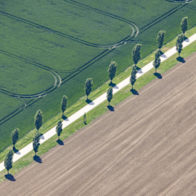
Aerial view of a poplar avenue in farmland in Klosterzimmern, Deiningen, Donau-Ries, Swabia
-

€100.00 plus VAT if applicable.
Aerial view of a circular parking lot, Schrobenhausen, Upper Bavaria
-

€100.00 plus VAT if applicable.
Aerial view of a double circle farmers painting in Herrnberchtheim, Ippesheim, Neustadt an der Aisch-Bad Windsheim, Middle Franconia
-

€150.00 plus VAT if applicable.
Aerial view of a person walking the dog in Altenmarkt a.d.Alz, Traunstein, Upper Bavaria
-

€100.00 plus VAT if applicable.
Aerial view of a blue tractor mowing in Haseneck, Taching am See, Upper Bavaria
-

€100.00 plus VAT if applicable.
Aerial view of a stone spiral in Frauenhof, Teublitz, Upper Palatinate
-

€100.00 plus VAT if applicable.
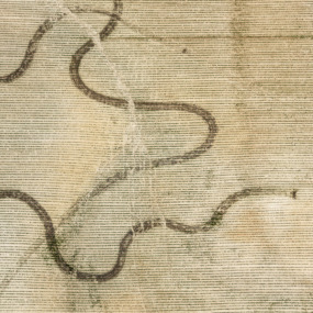
Aerial view of animal tracks in a barley field in Steinsdorf near Altmannstein, Eichstätt, Upper Bavaria
-
€150.00 plus VAT if applicable.
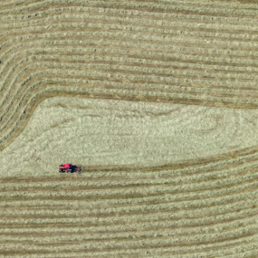
Aerial view of a red tractor turning hay in Helmer near Bernbeuern, Weilheim-Schongau, Upper Bavaria
-

€150.00 plus VAT if applicable.
Aerial view of tracks in a cornfield in Latzelsberg, Rottal-Inn, Lower Bavaria
-

€100.00 plus VAT if applicable.
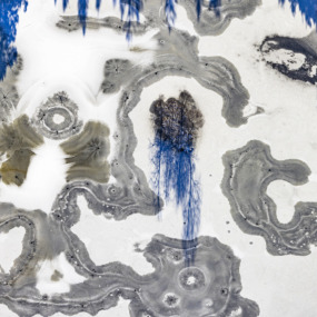
Aerial view of an algal mat with strange structures in the Regen River near Miltach, Upper Palatinate
-
€100.00 plus VAT if applicable.
Aerial view of an algal mat with strange structures in the Regen River near Miltach, Upper Palatinate
-
€150.00 plus VAT if applicable.
Aerial view of a water basin in a gravel pit, Oberwattenbach, Landshut, Lower Bavaria
-

€100.00 plus VAT if applicable.
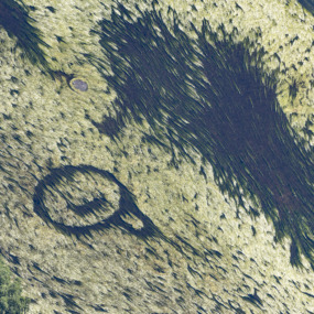
Aerial view of mysterious tracks in the grassland in Grossgundertshausen, Mainburg, Lower Bavaria
-

€100.00 plus VAT if applicable.
Aerial view of a modern chicken coop in Lohrbach near Insingen, Ansbach, Middle Franconia
-

€100.00 plus VAT if applicable.
Aerial view of a snail made of stone in Frauenhof near Teublitz, Schwandorf, Upper Palatinate
-

€100.00 plus VAT if applicable.
Aerial view of an old tractor harrowing in an agricultural wasteland, Grub near Kelheim, Lower Bavaria
-

€100.00 plus VAT if applicable.
Aerial view of an asparagus field covered in white foil in Inchenhofen, Aichach-Friedberg, Swabia, Bavaria
-

€150.00 plus VAT if applicable.
Aerial view of tracks in a field in Allershausen, Freising, Upper Bavaria
-

€150.00 plus VAT if applicable.
Aerial view of a solar field with dual-axis tracking solar modules in Schönthal, Cham, Upper Palatinate
-

€150.00 plus VAT if applicable.
Aerial view of the meanders of the Wieseth river near Bechhofen, Middle Franconia
-

€100.00 plus VAT if applicable.
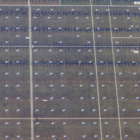
Aerial view of rows of rental cars in Neunburg vorm Wald, Upper Palatinate
-

€100.00 plus VAT if applicable.
Aerial view of a shadow church in Haindling near Geiselhöring, Straubing-Bogen, Lower Bavaria
-

€100.00 plus VAT if applicable.
Aerial view of the cemetery in Neunburg vorm Wald, Schwandorf, Upper Palatinate
-

€100.00 plus VAT if applicable.
Aerial view of the Kleine Laber river near Sallach, Straubing-Bogen, Lower Bavaria
-
€100.00 plus VAT if applicable.
Aerial view of the roofscape of the BMW Plant 2.6 construction site near Straßkirchen, Straubing-Bogen, Lower Bavaria
-

€100.00 plus VAT if applicable.
Aerial view of the Schlossallee in Valley, Miesbach, Upper Bavaria
-

€150.00 plus VAT if applicable.
Aerial view of the hay harvest in the triangle in Tuntenhausen, Rosenheim, Upper Bavaria
-

€100.00 plus VAT if applicable.
Aerial view of a row of green MVV buses in Germering, Munich, Upper Bavaria
-

€150.00 plus VAT if applicable.
Aerial view of four trees in an agricultural landscape in Oberbabing, Landshut, Lower Bavaria
-

€150.00 plus VAT if applicable.
Aerial view of a tractor with a harrow leaving tracks in the field, Velden, Landshut, Lower Bavaria
-

€150.00 plus VAT if applicable.
Aerial view of a tractor with a harrow leaving tracks in the field, Velden, Landshut, Lower Bavaria
-
€100.00 plus VAT if applicable.
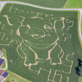
Aerial view of a corn maze shaped like a piglet in Ed near Tann, Rottal-Inn, Lower Bavaria
-

€100.00 plus VAT if applicable.
Aerial view of a field path with a tree in Baldham, Ebersberg, Upper Bavaria
-
€150.00 plus VAT if applicable.
Aerial view of a chestnut tree with a field chapel among flowering rapeseed fields in Biburg, Fürstenfeldbruck, Upper Bavaria
-

€150.00 plus VAT if applicable.
Aerial view of a row of trees in an agricultural landscape in Vatersdorf, Landshut, Lower Bavaria
-

€150.00 plus VAT if applicable.
Aerial view of the rows of linden trees at the new southern cemetery in spring in Munich-Perlach, Upper Bavaria
-

€100.00 plus VAT if applicable.
Aerial view of the rows of linden trees at the New South Cemetery in Munich-Perlach, awaiting spring, Upper Bavaria
-

€100.00 plus VAT if applicable.
Aerial view of a track in a field in Weiding, Cham, Upper Palatinate
-

€150.00 plus VAT if applicable.
Aerial view of the rows of linden trees at the New South Cemetery in Munich-Perlach in autumn, Upper Bavaria
-

€150.00 plus VAT if applicable.
Aerial view of a tree nursery in Zainach, Rott am Inn, Upper Bavaria
-

€150.00 plus VAT if applicable.
Aerial view of the corn harvest with semicircle, Marklkofen, Dingolfing, Lower Bavaria
-

€150.00 plus VAT if applicable.
Aerial view of the garden at Fürstenfeldbruck Monastery, Upper Bavaria
-

€100.00 plus VAT if applicable.
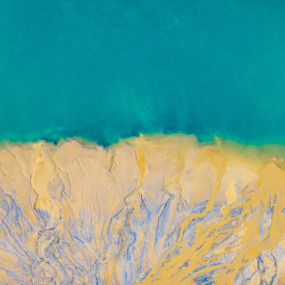
Aerial view of a foil field with a tear in the foil in Dattensoll, Main-Spessart, Lower Franconia
-
€100.00 plus VAT if applicable.
Aerial view of the grounds of the Diederstetten riding club, Ansbach, Middle Franconia
-

€150.00 plus VAT if applicable.
Aerial view of an acute-angled triangle in a field in Karlskron, Neuburg-Schrobenhausen, Upper Bavaria
-

€150.00 plus VAT if applicable.
Aerial view of a farmer’s painting with loops in Egling an der Paar, Landsberg am Lech, Upper Bavaria
-

€150.00 plus VAT if applicable.
Aerial view of the Munich-North marshalling yard, Upper Bavaria
-

€100.00 plus VAT if applicable.
Aerial view of three rows of terraced houses in Bischofswiesen, Berchtesgadener Land, Upper Bavaria
-

€100.00 plus VAT if applicable.
Aerial view of a red tractor turning hay, Obersteinbach, Neustadt an der Aisch-Bad Windsheim, Middle Franconia
-

€150.00 plus VAT if applicable.
Aerial view of a tractor working in a field in Baldern, Bopfingen, Baden-Wuerttemberg
-

€100.00 plus VAT if applicable.
Aerial view of the renaturation of the Schneidheimer Sechta river, Kirchheim am Ries, Ostalbkreis, Baden-Württemberg
-
€100.00 plus VAT if applicable.
Aerial view of a storage area for brand new bricks, Vatersdorf, Landshut, Lower Bavaria
-

€150.00 plus VAT if applicable.
Aerial view of tracks in arcs from field cultivation in a field near Freidling, Landshut, Lower Bavaria
-

€150.00 plus VAT if applicable.
Aerial view of the sludge in the settling basin of a lime works in Lauterhofen, Neumarkt, Upper Palatinate
-

€100.00 plus VAT if applicable.
Aerial view of a labyrinth in the Roman Park Ruffenhofen, Ansbach, Middle Franconia
-

€150.00 plus VAT if applicable.
Aerial view of work in the hop field in Schatzhofen, Landshut, Lower Bavaria
-

€100.00 plus VAT if applicable.
Aerial view from the roof of a huge logistics hall in Gündlkofen, Landshut, Lower Bavaria
-
€150.00 plus VAT if applicable.
Aerial view of the island in the frozen Großer Kesselsee lake in Reitmehring, Wasserburg am Inn, Upper Bavaria
-

€150.00 plus VAT if applicable.
Aerial view of the island in the frozen Großer Kesselsee lake with shadows in Reitmehring, Wasserburg am Inn, Upper Bavaria
-

€150.00 plus VAT if applicable.
Aerial view of the teaching and demonstration farm for fruit growing in Deutenkofen, Landshut, Lower Bavaria
-

€150.00 plus VAT if applicable.
Aerial view of the teaching and demonstration farm for fruit growing in Deutenkofen, Landshut, Lower Bavaria
-

€150.00 plus VAT if applicable.
Aerial view of a drained fish pond in Aschheim, Munich, Upper Bavaria
-

€150.00 plus VAT if applicable.
Aerial view of a circular figure in the field near Gräfendorf, Main-Spessart, Lower Franconia
-

€100.00 plus VAT if applicable.
Aerial view of a poultry breeding facility in Wolframs-Eschenbach, Ansbach, Central Franconia
-

€150.00 plus VAT if applicable.
Aerial view of a barn in a field of rape near Laufzorn manor, Oberhaching, Munich
-

€150.00 plus VAT if applicable.
Aerial view of graphic traces at hay turning in Reinertshof, Ostallgaeu
-

€150.00 plus VAT if applicable.
Aerial view of a fresh green line of trees at the Streiflacher Weg in Munich-Freiham, Upper Bavaria
-

€100.00 plus VAT if applicable.
Aerial view of a circular island in a grain field
-

€100.00 plus VAT if applicable.
Aerial view of the stone labyrinth near Saint Theobald in Geisenhausen
-

€150.00 plus VAT if applicable.
Aerial view of a tree in a point of a field
-

€150.00 plus VAT if applicable.
Aerial view of row of trees at the roadside between wheatfields
-

€150.00 plus VAT if applicable.
Aerial view of field works of a farmer
-

€100.00 plus VAT if applicable.
Aerial view of hay turning traces near Uffing
-

€100.00 plus VAT if applicable.
Aerial view of green circular planting in Rott am Inn
-

€150.00 plus VAT if applicable.
Aerial view of a tractor turning hay
-
€150.00 plus VAT if applicable.
Aerial view of traces of erosion and of a farmer in a crop field near Neufahrn-Schaltdorf
-

€100.00 plus VAT if applicable.
Aerial views of garages with blue doors
-

€150.00 plus VAT if applicable.
Aerial view of a heart in the meadow